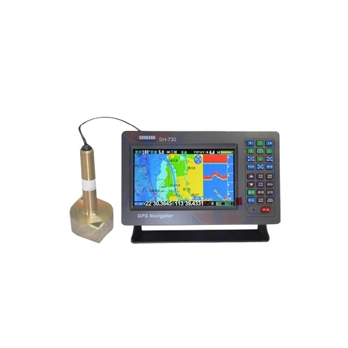
Marine GPS navigator chart fishery fish detector depth sounder multi-function three-in-one
-
Physical index
Waterproof, moisture proof, anti-fog
Appearance size 262x172x85mm
Working environment -15°C-70°C, relative
humidity below 95%Storage temperature -40°C-80°C
GPS receiving characteristics
Receiver parallel 50 channels
Accuracy less than 5 meters
Receiving frequency L1 (1575.42±MHz)
Positioning time is less than 3 seconds
(heat evoke)Tracking speed 0.1 to 1000 knots
Navigation performance
Navigation screen Positioning screen,
satellite screen, compass screen, chart screen, road screen, fishing screenDay/night mode is available, and the boat
can be used to navigate the center.The lighthouse shows a bright, steady
light. The latest chart dataAlarm mode Arrival alarm, yaw alarm, anchor
alarm, time alarm, clock alarmMemory capacity 3000 waypoints, 20 routes,
10 destinations per route3000 markers, 1 flight path
totaling 49,152 track pointsTrack features Special track protection and
can delete any trackElectrical parameters
Display TFT 7 吋 true color LCD
Power supply DC10V-DC24V
Power Maximum power consumption 4W
Fishing probe parameters
Adjust the detection accuracy method Hand /
AutoFishing frequency 200kHz
Fishing gun power 300W
Standard configuration
Power cord
2. Fixing bracket
3. Chinese manual, simple manual
4. Antenna
محصولات مرتبط
نقد و بررسیها
هنوز بررسیای ثبت نشده است.
نقد و بررسیها
هنوز بررسیای ثبت نشده است.